Messages are welcome on any subject relating to Troopers Hill Local Nature Reserve; the surrounding area of St George and Crews Hole or any of Bristol's Parks and Green Spaces.
Friends of Troopers Hill Forum - www.friends-forum.org.uk
|
||
| Return to Website | ||
 First First |
 Prev Prev |
 Reply Reply |
 Forum Forum |
Next  |
Last  |
| Viewing Page 1 of 1 (Total Posts: 7) |
| Author | Comment |
Rob

 May 18, 07 - 8:01 PM |
Interpretation board and Leaflets
Some of you might have noticed a new interpretation board appear on the hill this morning, this has been funded by Bristol Parks. Unfortunately it is taller than the one Bristol Parks ordered. Hopefully new shorter legs will be fitted next week so that children and people in wheelchairs can read it more easily - it will also then be less visible on the skyline and not block the view from the new bench. Apart from the height though I hope you like it. The design of the board can be seen here. We have also finalised the design of our Big Lottery funded new leaflet and they are being printed at the moment. Final leaflet design. You will notice that the map and illustrations on both the board and the leaflet are the same. This is a result of Friends of Troopers Hill working closely with Bristol Parks so that we both benefit. Bristol Parks have paid for some of the illustrations and this has allowed us to include more on our leaflet that we budgeted for. In return we allowed them to use the map that we had commisioned. I hope you like both of them, I would like especially to thank Clare of dandi creative design who designed both and who completed the work despite suffering from the effects of a nasty car accident. |
|
Roger
May 18th, 2007 - 8:15 PM |
I must pop up and take a look in the morning, not been up there for at least a week :-) |
|
Rob
May 22nd, 2007 - 8:33 PM |
3000 copies of our new leaflets were delivered today, they look great - come along to next week's meeting if you want some copies. We will also be deciding then how and where we should distribute them. The interpretation board was lowered today to its final height, and a new sign board was put up at the Malvern Road entrance to Troopers Hill Field. This has room for four A4 posters or six at a squeeze so we can also use it to advertise other local community events such as the music at St Aidans. |
|
Rob
Jun 12th, 2007 - 7:07 PM |
Having completed our first leaflet about the wildlife of the hill we now need to think about the next part of the project. We intend to produce two more leaflets one about history and the other on geology. We will be holding a meeting to get some initial ideas together on Tuesday 19th June at 7.30pm at our house. If anyone is interested in taking part please email rob@troopers-hill.org.uk for details. |
|
Susan
Jun 19th, 2007 - 11:03 PM |
Many thanks to Pauline and Roy for their input. The proposed outline design for the 2 A4 leaflets, one for Troopers Hill history, the other for Troopers Hill geology has been put together. The format will be A4 with two vertical folds when looking at the page in landscape. The first side on view will show the bottom chimney for the history leaflet and for the geology leaflet we want an intesting photo taking in the side of the gully, showing the rock there, but including the chimney on the top. Photographic contributions will be much welcomed. Inside both leaflets we are thinking about both of them being opened out in landscape format and having something like a central picture with words around the central picture. Rob and I both have to go and find out whether we can get permission for our respective pictures. Mine is a recreation of the Carboniferous age from a South Gloucestershire Geology leaflet, Rob's is a print of the pumphouse chimney that used to be further up Troopers Hill Rd. The middle back panel will have the stuff about who owns and manages Troopers Hill, plus the various logos and references to the other leaflets. The final back panel will have - for history snippets of different people's memories - for geoology information about Coal, Fireclay and Pennant sandstone. Rob will be doing his own text for the history leaflet, I will be borrowing heavily from some text that Eileen Stonebridge of RIGS (Regionally Important Geological and Geomorphological Sites) wrote for us. This is Eileen's original text "Geology and Landscape at Trooper’s Hill Trooper’s Hill is part of a plateau surface formed of Pennant Sandstone. The hill appears to be isolated from the rest of the plateau due to erosion on the southern side by the River Avon, which has caused steep slopes to form. On the eastern side there is a steep fairly narrow valley which is a tributary of the River Avon. A smaller valley lies to the west of the hill where there is a large landslip. To the north, the separation from the generally level land surface is less distinct. The summit of the hill is about 70 metres above sea level, which makes it a good viewpoint, especially to the south and west. The Rocks The Pennant Series is the name given to a group of rocks, which are part of the Upper Coal Measures, some 300 million years old. These are in the age which geologists call the Carboniferous, so called because there is a great deal of carbon, including coal, locked up in the rocks. The Coal Measures were formed when the land, which now makes up the British Isles lay far to the south, somewhere near the equator. The land was very swampy and the climate was very humid. The plants, which grew there, included giant horsetails and ferns. These rotted down; eventually to become coal as the material was compressed by the weight of later sediments. The clayey soil in which the plants grew in turned into bands of clay. These are much weaker than the sandstone. From time to time the whole area was covered by sands and fine gravels as the rivers which fed the area changed their course, just as happens in the Mississippi delta today. As time went by there was more and more sandy material and the swamps disappeared. At the end of the Carboniferous there was a great upheaval of the earth’s crust so that the rocks were broken and folded. At Trooper’s Hill we are on an arm of one of these great folds and the rocks dip to the south at an angle of 30 degrees. If you look carefully at the rocks exposed on the quarry faces it is possible to tell that they were deposited under water as the currents in the streams caused little dunes to form which were the cut into as the current changed direction. This is called this cross bedding. The Geological History After the great upheavals at the end of the Carboniferous, some 290 million years ago our area had drifted northwards and was in the hot dry desert climate belt, comparable to the Sahara Desert today. Rocks of this age, the Triassic are found beneath the old part of the City of Bristol and beneath Bedminster, that is much of the low-lying ground seen to the south from Trooper’s Hill. The next period of geological time was the Jurassic when; firstly fine clays were deposited in warm seas, followed by limestones. The whole sequence of deposition was from 205 to 130 million years ago. Since that time a great deal of material has been eroded, but the succession of clays and limestones can be found on Dundry Hill. The Quaternary Ice Ages There are long gaps in our detailed knowledge as to whether rocks were deposited and then eroded or whether they were never deposited in the first place! This is true of the last 3 million years. We know from evidence from cores from the seabed, that there have been at least 22 changes of climate from severely cold to temperate, but there is very little evidence of these events on the land in the Bristol area. Two local landscape features originated in the cold periods, the steep now dry valleys and the landslips. During cold periods the ground freezes, but summer melting and the final melting as temperature increases, means that there is a great deal of water available. This forms short steep river valleys such as the one to the east of Trooper’s Hill and larger rivers, such as the River Avon were much bigger. Rocks such as shales and mudstones became mobile when the thawing occurred resulting in landslips like the one on the south-western face of Trooper’s Hill. Geological Resources Three important resources are in the area, coal, clay and sandstone. The coal was mined from the shallow seams which outcrop at the surface and deeper down. Fire clay was used for bricks and the stone was quarried for building stone. The extraction of these resources changed the shape of the land. Steep quarry faces replaced the natural slopes and the dumping of waste formed artificial slopes and destabilised the old landslips. Council tipping in the area after 1967 further upset the slope stability which was then stabilised in 1969 with a concrete berm. The smelting and other works at Crew’s Hole during the 19th and early part of the 20th centuries caused the natural vegetation to die which enabled soil erosion to occur. Acidification of the soil was caused by to sulphur and carbon dioxide deposited from fall out from the chimneys. This has resulted in vegetation, which is quite unlike that elsewhere on the Pennant sandstone in Bristol, though it is similar to that on the hills in South Wales, which are in the proximity of former smelting sites. Trooper’s Hill today is the result of the impact of industrial processes on a particular association of rocks and soils. " If you are interested to know more about RIGS see www.ukrigs.org.uk. Troopers Hill has been proposed as a RIGS - it would be lovely the application could get through the system in time for the publication of the leaflet. Any thoughts on the design so far will be very welcome. We are looking to repeat the Troopers Hill Nature Reserve heading of the orignal leaflet and possible some words across the photo as in the original leaflet. All the best, Susan |
|
Ian
Jun 20th, 2007 - 7:54 AM |
Susan - That's a very interesting article and explains quite a bit about the area. If you use RIGS though it might help to spell it out in full - Regionally Important Geological and Geomorphological Sites. Hope this helps? |
|
Susan
Jun 20th, 2007 - 11:10 PM |
Thanks, Ian, but I think I did - see "Rob will be doing his own text for the history leaflet, I will be borrowing heavily from some text that Eileen Stonebridge of RIGS (Regionally Important Geological and Geomorphological Sites) wrote for us." or have I done a typo somehow or missed doing it on the first reference? In any case thanks for the feedback. By the way I now have my cardboard and hope to try out a little sliding after tomorrow's work party. I am hoping my almost twin, Liz, will join in too. All the best, Susan |
| First |
Prev |
Reply |
Forum |
Next |
Last |
 bravenet.com
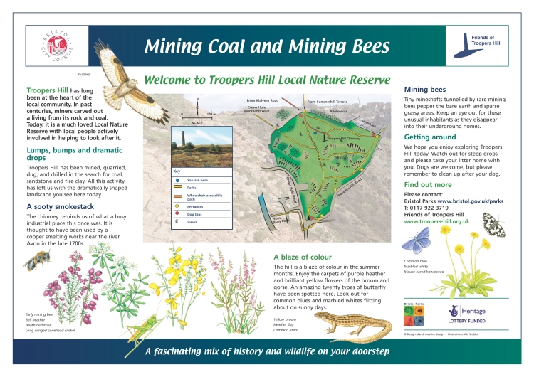